

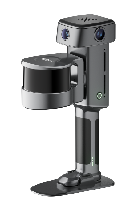
Lixel L3
The flagship high-accuracy spatial scanner — accuracy meets photorealism.
- 5 mm relative accuracy
- 4K HDR true-color vision system
- Point cloud, mesh, and 3DGS output
QRC transforms existing buildings, facilities and infrastructure into accurate digital information your teams can use to plan, design, build and operate with nationwide reality capture services or technology deployed inside your organization.
One Call. One Team. One Accountable Partner.
Recent work: Charleston Place Hotel · The Citadel · McGraw-Hill Building · AB Tech Campus (with LS3P)
1,125+
Scans Completed
630+
Sites Captured
845M+
Square Feet Documented
450+
Clients Served
US & Canada
Service Footprint
Getting Started
Nationwide Reality Capture Services
Hybrid Project Delivery
Technology, Training, and Support
Deployment Strategy
Deploying reality capture technology isn't a one-size-fits-all proposition. The strategy you ultimately deploy will be determined by your operational realities. QRC offers Services when you need Capacity — and Technology when you want Control.
Portfolio Scale & Frequency
Are you managing continuous, multi-site enterprise assets or ad-hoc adaptive-reuse projects?
Resources & Domain Expertise
Do you have dedicated in-house specialists, or do you require scalable, on-demand execution?
CapEx vs OpEx Optimization
How are your capital and operational budgets structured to maximize ROI?
Deliverable Specifications
What exact spatial outputs are required to drive project success?
Whether you are implementing XGRIDS handheld SLAM hardware for internal teams, outsourcing precision Scan-to-BIM workflows, or deploying a hybrid strategy, QRC delivers the operational alignment your business demands.
OUR SERVICES
Explore our full suite of surveying, modeling, and design support solutions.
High-speed terrestrial scanning for interiors, exteriors, and complex sites — millimeter-accurate point clouds ready for downstream workflows.
View ServiceUAV-mounted LiDAR and photogrammetry for topographic surveys, site overviews, and large-area capture where ground access is impractical.
View ServiceRegistered point clouds converted into intelligent Revit models — LOD 200–400 — for design, coordination, and construction.
View ServiceAs-built floor plans, elevations, sections, and reflected ceiling plans drafted from scan data for renovation and adaptive-reuse projects.
View ServiceClash-free mechanical, electrical, and plumbing coordination powered by accurate scan-to-BIM models and point-cloud overlays.
View ServiceImmersive 360° walkthroughs and interactive digital twins for remote site access, marketing, and facility management.
View ServiceConceptual design, feasibility studies, and permit-ready documentation built on verified existing-conditions data.
View ServicePeriodic scan captures benchmarked against BIM to track construction progress, verify installations, and reduce rework.
View ServiceXGRIDS Technology — Authorized Reseller
QRC helps organizations across the built environment build and scale in-house reality capture capabilities that improve planning, accelerate project delivery, standardize documentation, and enable better decisions.
The flagship high-accuracy spatial scanner — accuracy meets photorealism.

Survey-grade real-time LiDAR scanner for complex enterprise assets.

The gold standard in lightweight scanning — 1,200 g with built-in RTK.

The first true spatial camera — 870 g, 3DGS native capture.
Sector Coverage


Selected Projects
From historic preservation to multi-site enterprise portfolios — see the deliverables behind the data.
Anchor Case StudyCampus-scale reality capture and LOD 200 Revit modeling for Asheville-Buncombe Technical Community College, delivered as a subconsultant to LS3P.
 Scan-to-BIM
500k+ Sq Ft Captured
Digital Twin1,100+ Scan Positions
 Aerial LiDAR
Old City Jail · Survey-Grade Capture
 Scan-to-BIM
300k+ Sq Ft Documented
THE QRC ADVANTAGE
By combining nationwide field capability, experienced AEC professionals, advanced digital workflows, and strategic consulting, we transform existing conditions into trusted project intelligence that teams can confidently use to plan, design, build, and operate.
One trusted partner for projects across North America.
Reliable data you can trust for design and construction.
Reality capture services, technology, training, and implementation under one roof.
Helping teams successfully adopt and scale reality capture.
Experienced teams and scalable resources for projects that cannot wait.
We understand project delivery because we have managed projects ourselves.
Carefully selected best-in-class technology partners like XGRIDS to deliver scalable reality capture solutions.
Government & Enterprise Ready
Whether you need nationwide scanning services, or want to build your own in-house reality capture capability, QRC can help.


